| Some of the databases used to create base map themes and
map overlays are available for the user to search.
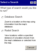 Your
choices can be either "Database Search" or "Radial Search".
The "Database Search" will locate a single property or road name.
The "Radial Search" will conduct a neighborhood or proximity search
from a property or on-screen object and display in a text box all objects
that are within a specified distance (e.g. 300 ft). Your
choices can be either "Database Search" or "Radial Search".
The "Database Search" will locate a single property or road name.
The "Radial Search" will conduct a neighborhood or proximity search
from a property or on-screen object and display in a text box all objects
that are within a specified distance (e.g. 300 ft).
|
|
 Steps
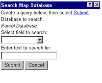
to run a Database Search Steps
to run a Database Search
- Select the database (if only one database is searchable the name of that database will be italicized)
- Select the "field" to search on. (e.g. parcel number, owner name)
- Enter the text to search on. (e.g. 005-008-001-00, or Smith)
If you selected parcel number, type in a valid property number
If you selected owner name, type in an owner name
- Click "Submit"
The object that was found will be highlighted in yellow.
|
|
 Steps
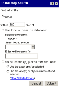
to run a Radial Search Steps
to run a Radial Search
- Select the database (if only one database is searchable the name
of that database will be italicized)
- Set the distance that you want to use (default is 300ft)
Option 1:
If you want to conduct a 300 ft radial search from the boundaries of a
particular property then click the radio button in front of "this location
from the database"
- Select the field to search on. (e.g. parcel number, owner name etc)
- Enter the text to search on (e.g. 005-008-001-00, or Smith)
If you selected parcel number, type in a valid property number
If you selected owner name, type in an owner name
- Click "Submit"
Results:
The object that was searched for (parcel number or owner name) will be
highlighted in orange; all those properties within specified search distance
will be highlighted in yellow. The text box will also display important
information regarding the search results.
|
|
Option 2:
If you want to conduct a radial search from a spot on the map then click
the button in front of "these location(s) picked from the map":
The select the button for either "Use the exact spot(s) selected"
or "Use the label(s) or object(s) nearest spot selected"
- The option "Use the exact spot(s) selected" allows the user
to select one or multiple spots on the map to conduct this radial search.
The selected points will be numbered with a blue dot
- The option "Use the label(s) or object(s) nearest spot selected"
allows the user to click on the map and have existing on-screen items
(i.e. road labels, parcel centroids etc) be the intended radial search
object.
- Click "Submit"
Results:
The object that was searched for (parcel number or owner name) will be
highlighted in orange; all those properties within specified search distance
will be highlighted in yellow. The text box will also display important
information regarding the search results.
|