 |
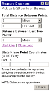
Measure Distances
Measure the distance between points:
- Click anywhere on the map and a purple circle with the number "1" appears.
- Click again, and a "2" displays, then a "3", etc. As you click, the following information appears in the Measure Distances window:
a. Total Distance between the points you have selected in two different units. You may change either of the units at any time.
b. Distance between last Two Points box - shows the distance between the last two points you have selected.
- Click "Close Loop" to measure from the last point back to the first point to create a closed loop.
- Click "Start Over" to clear all the points from the map and set all distances back to zero.
Determine the x/y coordinates for those points using Point Coordinates boxes :
- Coordinates for a point appear for that point number.
- To view coordinates for a previously selected point, change the number to a previously selected point, then press the Tab key on your keyboard.
Click "Cancel" to close the Measure Distances window and clear the purple markers from the map display.
|